Na Highway 620, Wollaston | Image 1

Na Highway 620

Wollaston

  • - bed - bath
$XXX,XXX Listed: $XXX,XXX
Sold

Sold on Apr 28, 2024

Note: Property is not currently for sale or for rent.

Sign in or Register • To view sold data & photos, an account is required by the Toronto Real Estate Board.
  • Type: Vacant Land

  • Lot Size: 260 x 500 Feet

  • Age: No Data

  • Taxes: $315 per year

  • Days on Site: 9 Days

  • Added: Apr 19, 2024 (1 week on market)

  • Updated:

  • Last Checked: 2 hours ago

  • MLS®#: X8251264

  • Listed By: Re/max country classics ltd.

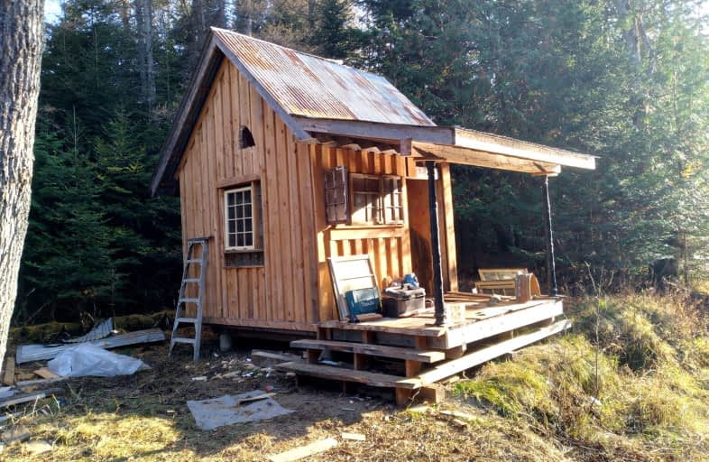
Waterfront 2-1/2 Acres with over 700 feet on Deer River on the edge of the hamlet of Coe Hill. The driveway into this property leads to a lovely level open area out of sight of the road and neighbours- an excellent place to build your home or getaway place. This is a very pretty spot on a little river with a mostly complete, very attractive 10 X 10 building right on the riverbank.

Extras

Hwy 620 to laneway beside #5726

Status

  • Days on Market: 9

  • Last Status: Sold

  • Sold Date: Apr 28, 2024

  • Closed Date: May 29, 2024

  • Expiry Date: Aug 31, 2024

  • Sold Price: $120,000

  • Unavailable Date: Apr 29, 2024

  • Input Date: Apr 19, 2024

  • Prior LSC: Listing with no contract changes

Property

  • Status: Sale

  • Property Type: Vacant Land

  • Area: Wollaston

  • Availability Date: On closing

Utilities

  • Electricity: Yes

  • Gas: No

  • Cable: No

  • Telephone: Yes

Building

  • Water Supply: None

  • Special Designation: Unknown

Fees

  • Tax Year: 2023

  • Tax Legal Description: PT LT 13 CON 9 WOLLASTON AS IN QR667141; WOLLASTON; COUNTY OF HA

  • Taxes: $315

Land

  • Cross Street: Hwy 620 At Deer Rive

  • Municipality District: Wollaston

  • Fronting On: North

  • Parcel Number: 401160212

  • Sewer: None

  • Lot Depth: 500 Feet

  • Lot Frontage: 260 Feet

  • Lot Irregularities: Lot Has Over 700Ft Ri

  • Acres: 2-4.99

  • Waterfront: Direct

  • Water Body Name: Deer

  • Water Body Type: River

  • Water Frontage: 225

  • Access To Property: Yr Rnd Municpal Rd

  • Easements Restrictions: Unknown

  • Water Features: Riverfront

  • Shoreline: Mixed

  • Shoreline: Natural

  • Shoreline Allowance: Not Ownd

  • Shoreline Exposure: W

  • Rural Services: Electr On Road

  • Waterfront Accessory: Bunkie

Sign in or Register • To view sold data & photos, an account is required by the Toronto Real Estate Board.

Car-Dependent

  • Almost all errands require a car.
0 /100

Somewhat Bikeable

  • Almost all errands require a car.
24 /100
JK-3

Cardiff Elementary School

Elementary: Public
19.25 km
JK-6

Coe Hill Public School

Elementary: Public
13.42 km
JK-8

Apsley Central Public School

Elementary: Public
10.98 km
JK-6

Birds Creek Public School

Elementary: Public
31.94 km
JK-8

Our Lady of Mercy Catholic School

Elementary: Catholic
26.96 km
JK-8

York River Public School

Elementary: Public
27.34 km
9-12

Norwood District High School

Secondary: Public
50.06 km
9-12

Haliburton Highland Secondary School

Secondary: Public
47.66 km
9-12

North Hastings High School

Secondary: Public
27.14 km
9-12

Campbellford District High School

Secondary: Public
60.47 km
9-12

Adam Scott Collegiate and Vocational Institute

Secondary: Public
61.79 km
9-12

Thomas A Stewart Secondary School

Secondary: Public
61.08 km
  • Coe Hill Park

    Coe Hill ON 12.57km
  • Petroglyphs Provincial Park

    2249 Northey's Bay Rd, Woodview ON K0L 2H0 24.01km
  • Riverside Park Bancroft

    Bancroft ON 27.5km
  • RBC Royal Bank ATM

    135 Burleigh St, Apsley ON K0L 1A0 11.25km
  • TD Bank Financial Group

    25 Hastings St N, Bancroft ON K0L 1C0 27.37km
  • TD Canada Trust Branch and ATM

    25 Hastings St N, Bancroft ON K0L 1C0 27.36km