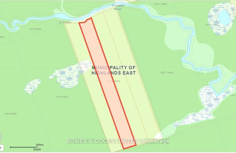
Irondale River, Hastings Highlands | Image 1

Irondale River

Hastings Highlands

  • - bed - bath
$XX,XXX est.*: $166/mo
For Sale

Added 2 months ago

Sign in or Register • To view all data & photos, an account is required by the Toronto Real Estate Board.
  • Type: Vacant Land

  • Lot Size: 333 x 3200 Acres

  • Age: No Data

  • Taxes: $75 per year

  • Days on Site: 4 Days

  • Added: Aug 26, 2024 (2 months ago)

  • Updated:

  • Last Checked: 3 hours ago

  • MLS®#: X9270522

  • Listed By: Bowes & cocks limited

LOOK HERE - 25 ACRES WITH 333+/- FEET OF FRONTAGE ON THE IRONDALE RIVER. FOLLOW THE TRAIL THROUGH CROWN LAND TO REACH THE RIVER, DEPENDING ON THE WATERLEVELS 4 WHEELERS HAVE DRIVEN ACROSS TO THE PROPERTY. LOCATED IN THE MIDDLE OF HUNDREDS OF ACRES OF CROWN LAND, THIS IS A UNIQUE OPPORTUNITY!

Upcoming Open Houses

  We do not have information on any open houses currently scheduled.

  Schedule a Private Tour -

Contact Us

Property

  • Status: Sale

  • Property Type: Vacant Land

  • Area: Hastings Highlands

  • Availability Date: on closing

  • Assessment Amount: $16,200

  • Assessment Year: 2024

Utilities

  • Electricity: No

  • Gas: No

  • Cable: No

  • Telephone: No

Building

  • Water Supply: None

  • Special Designation: Unknown

Fees

  • Tax Year: 2023

  • Tax Legal Description: LT 10 CON 5 MONMOUTH EXCEPT H158345, H165108, H272216 MUNICIPALI

  • Taxes: $75

Highlights

  • Feature: Other

  • Feature: River/Stream

  • Feature: Wooded/Treed

Land

  • Cross Street: county road 503

  • Municipality District: Hastings Highlands

  • Fronting On: South

  • Parcel Number: 392350157

  • Sewer: None

  • Lot Depth: 3200 Acres

  • Lot Frontage: 333 Acres

  • Lot Irregularities: LOT FRONTAGE & DEPTH

  • Acres: 25-49.99

  • Zoning: RU as per GEO

  • Waterfront: Direct

  • Water Body Name: Irondale

  • Water Body Type: River

  • Water Frontage: 101.49

  • Access To Property: Other

  • Easements Restrictions: Unknown

  • Water Features: Riverfront

  • Shoreline: Rocky

  • Shoreline: Sandy

  • Shoreline Allowance: None

  • Shoreline Exposure: N

  • Rural Services: Off Grid

Sign in or Register • To view all data & photos, an account is required by the Toronto Real Estate Board.

Car-Dependent

  • Almost all errands require a car.
0 /100

Somewhat Bikeable

  • Almost all errands require a car.
13 /100
4-8

Wilberforce Elementary School

Elementary: Public
21.20 km
JK-6

Buckhorn Public School

Elementary: Public
38.98 km
JK-8

Apsley Central Public School

Elementary: Public
30.04 km
JK-3

Stuart W Baker Elementary School

Elementary: Public
17.90 km
1-8

J Douglas Hodgson Elementary School

Elementary: Public
17.89 km
JK-8

Archie Stouffer Elementary School

Elementary: Public
25.21 km
9-12

Haliburton Highland Secondary School

Secondary: Public
17.93 km
9-12

North Hastings High School

Secondary: Public
46.51 km
9-12

Fenelon Falls Secondary School

Secondary: Public
48.65 km
9-12

Adam Scott Collegiate and Vocational Institute

Secondary: Public
64.37 km
9-12

Thomas A Stewart Secondary School

Secondary: Public
64.10 km
9-12

St. Peter Catholic Secondary School

Secondary: Catholic
66.30 km
  • Furnace falls

    Irondale ON 14.48km
  • Hangover Falls

    Haliburton ON 14.8km
  • Head Lake Park

    Haliburton ON 17.76km
  • BMO Bank of Montreal

    194 Highland St, Haliburton ON K0M 1S0 17.69km
  • C B C

    Skyline Dr, Haliburton ON K0M 1S0 17.71km
  • CIBC

    217 Highland St (Maple Ave), Haliburton ON K0M 1S0 17.71km